
Balsall Common Viaduct
The HS2 route will be elevated and travel along a viaduct as it passes Balsall Common on the north-eastern side of the existing Network Rail line.
The viaduct will cross over Station Road, Bayleys Brook, Heart of England Way Walk and the associated floodplain. It will also cross an area of native species grassland with trees, and a wetland close to Bayleys Brook that includes a number of fishing lakes.
To improve connections the Kenilworth Greenway will be extended to Station Road on the south-eastern side of the existing railway line and a further extension towards Lavender Hall is currently under consideration. Options for cycling and bridleway extensions are also being considered.
Viaduct construction
Balsall Common Viaduct will be 425 metres long and approximately 10 metres above ground level. It will sit on 16 piers, which, through construction refinements, have been reduced in size by as much as 17% for single piers and 28% for double piers, giving the structure a lighter appearance.
The beams and parapet, for safety and emergency access to the viaduct, will be precast to increase safety and efficiency on site with haul roads built off Lavender Hall Lane and Park Lane compound used for delivery to reduce the impact on local roads. Environmental impact will also be limited with both temporary and permanent diversions of the existing waterway.
Viaduct design
The design aims to minimise the impact of HS2 on the landscape, local ecology, and views of the countryside, maintain existing public rights of way, enhance local habitats, and respect the existing rural character of the landscape by specifying plant species found locally.
Planting and species selection was a key focus, with the plans including wet woodland planting using native species to the local area; mixed native woodland plants such as midland hawthorn and black poplar, two notable local species; woodland edge planting to provide screening; and hedgerow planting to improve wildlife connections.
Reflecting the historic local growing of flax for weaving into linen, an alternative grass species mix will incorporate blue flowered plants including blue flax, cornflower and forget-me-nots. Bird boxes will be added in the trees in various locations to serve common bird species such as robin, blue tit and great tit.
A realignment of Bayleys Brook will increase habitat for fish, aquatic invertebrates and potentially water vole. Design changes have also reduced the size of the railway embankment running parallel to Bayleys Brook by 75 metres, improving the resiliency of the area to flooding, and enhancing views through the viaduct to the wider landscape.
Design engagement

Slide 1 of 14: Balsall Common viaduct over Station Road. Current design - polished concrete with pattern.

Slide 2 of 14: Balsall Common viaduct over Station Road. New design option - red.

Slide 3 of 14: Balsall Common Viaduct over Station Road. New design option - green.

Slide 4 of 14: Balsall Common Viaduct over Station Road. New design option - plain.

Slide 5 of 14: Balsall Common Viaduct abutment. Current design - polished concrete with pattern.

Slide 6 of 14: Balsall Common Viaduct abutment. New design option - red.

Slide 7 of 14: Balsall Common Viaduct abutment. New design option - green.

Slide 8 of 14: Parapet brick pattern

Slide 9 of 14: Parapet ram's horn pattern

Slide 10 of 14: Parapet Forest of Arden pattern

Slide 11 of 14: Parapet weave pattern

Slide 12 of 14: Artist's impression of Balsall Common Viaduct once complete.

Slide 13 of 14: Artist's impression of Balsall Common Viaduct once complete.
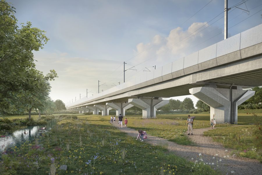
Slide 14 of 14: Artist's impression of Balsall Common Viaduct once complete.
Key facts
- Length: 425m
- Height: 10m
- Number of piers: 16
- Construction approach: Precast beams and parapet mean increased safety and efficiency on site.
Explore the HS2 route

Archaeology
The map displays information about our archaeological sites along the route.

Green Corridor
The map displays information about our environmental sites along the route.

HS2 funded projects
The map displays information about our funded community and business projects along the route.
Keeping you informed

Stay informed about the works
Find information about HS2 works and activities taking place in your area.

Managing impacts of construction
Find out information about how we manage construction impacts.

Construction look-ahead
Read our three-month lookahead for associated work in Solihull.

Find out what HS2 means for Solihull
This section provides you with information about HS2 works and developments in your area.
Find out more